


The US military footprint in northeastern Syria
Current bases in SDF-controlled territory and other somewhat relevant sites
This is a brief open source guide to the US military’s presense in SDF-controlled northeastern Syria. Below I highlight the nine bases in operation since the late 2019 partial withdrawal from Syria that saw the military vacate several bases in the Aleppo and al-Raqqah governorates, built in previous years as part of the anti-Islamic State campaign. Seven of these nine bases are located in al-Hasakah, while two are found in Deir ez-Zour. Additionally I included several other sites linked to the American deployment but seemingly not hosting a full time presence. The Tanf base located in the Homs governorate at the Jordanian and Iraqi borders is not included here.
The amount of information openly available on these sites varies: some feature prominently in US military media and western press reports, others we only catch glimpses of via local reporting. We have the official military names for just four of these bases, but pretty much all are referred to by several names depending on who is discussing them. During the 2023-24 rocket and drone attacks carried out by Iranian-backed militias targeting the US military in Syria, linked media outlets would occasionally use different names for the same sites while reporting attacks.
This opacity and the confusion regarding these sites - along with the non-zero chance that President Trump initiates a full withdrawal at any point - is my impetus for this guide. Below I include all the names (without spelling variations) that I’ve come across for each site, satellite imagery and coordinates, photos of and related to the base if available, and short descriptions. I have no expertise in military hardware so the latter are rather barebones. Hopefully this provides some clarity as to the current US military footprint in the northeast, which hosts the vast majority of the 2,000 servicemen reportedly deployed to Syria.
It should also be said that a good portion of this work stems from identifications and geolocations published to Twitter by obretix over the years.

(above) A map I made mid-2024 showing the nine current US bases (black), the bases vacated in late 2019 (grey), in relation to the 2024 front lines. The dotted line and name “Eastern Syria Security Area” came from a map included in the 2023 ‘Discord Leaks.’ Most these names are not official, ie. ‘Lawn chair’ is a reference to a 2018 NYT article.
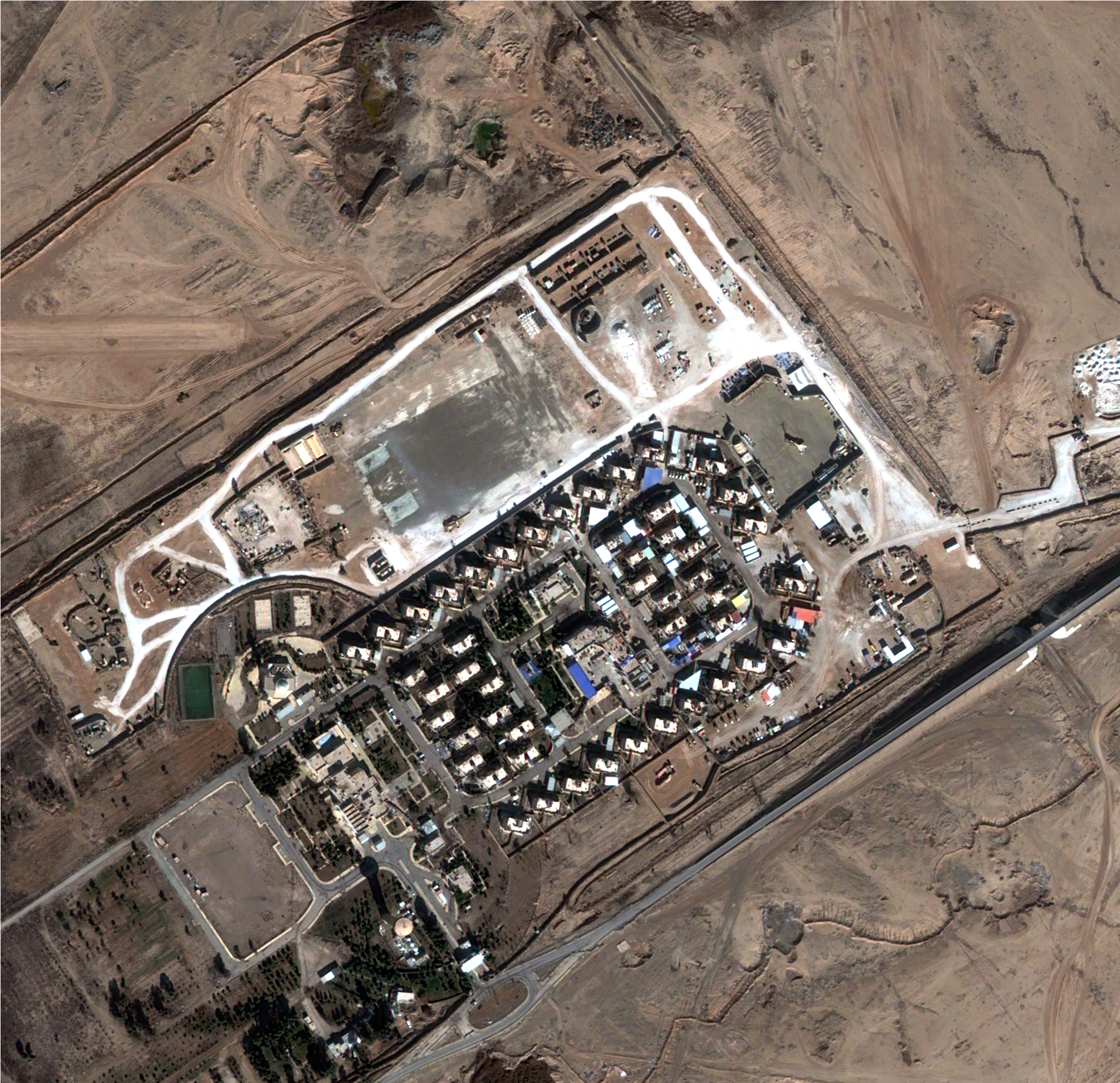
Rumailan Landing Zone (RLZ)
aka Kharab al-Jir, Abu Hajar airstrip. al-Hasakah, 36.901864, 41.990260.

RLZ is located outside the village of Kharab al-Jir, in the al-Ya’rubiyah subdistrict of northeastern al-Hasakah, approximately 12km from the Iraqi border. This area has been under YPG control since October 2013. The US began building the base in January 2016 and it has seen subsequent expansion, particularly around the 2019 following the almost-withdrawal of US troops from Syria and in 2023/24 in response to rocket and drone attacks launched by Iran-backed groups. Previously the area consisted of agricultural fields and a rudimentary runway known as the Abu Hajar airport, previously operated by the al-Hasakah Agricultural Directorate.
The base is made up of a 1.6km2 walled off area including a 1.35km long runway, helipads, numerous fortifications, buildings, tents, military and logistical vehicles, mostly clustered in the base’s northwestern corner.
Images below: from Gen. Kenneth F. McKenzie, Jr.’s 2020 visit, from a Oct 2020 DoD compilation, video published by formerly deployed US soldier, C-17 visible Oct 2022, Apache helicopters visible Sep 2020, Aerostat visible May 2023, RLZ patch for sale.


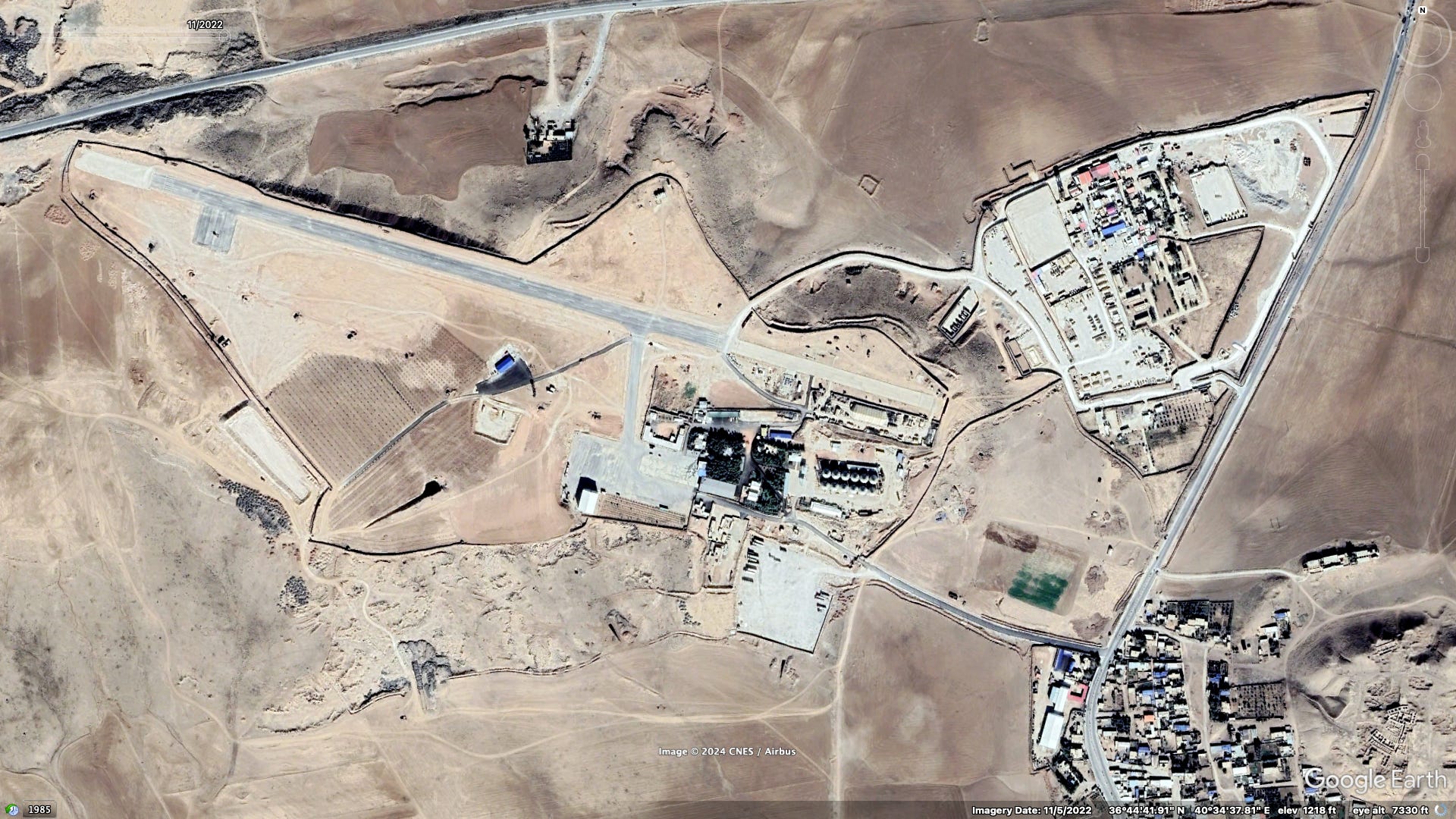
Patrol Base Shaddadi
aka PB Shaddadi. al-Hasakah, 36.046816, 40.725689.
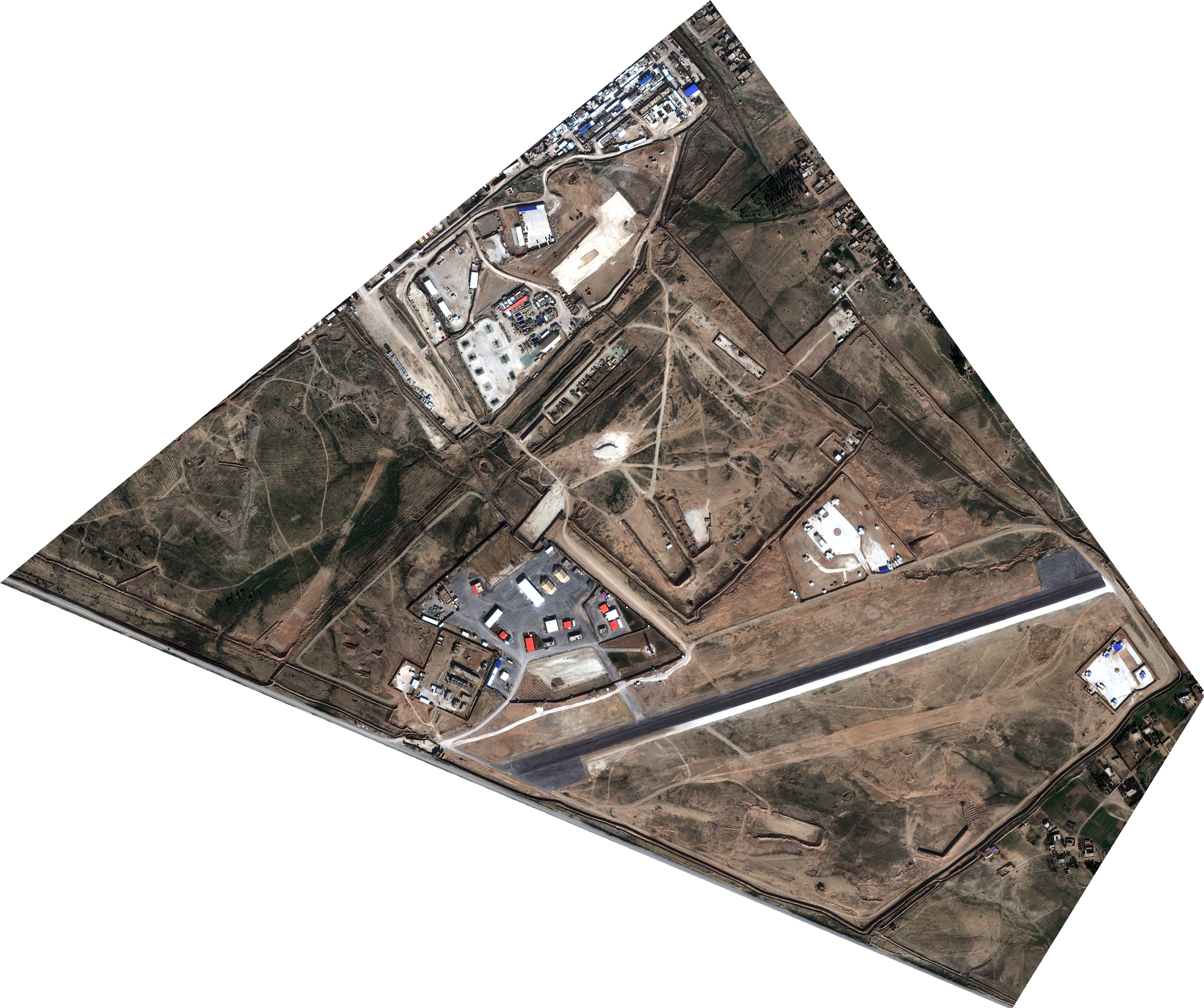
Patrol Base Shaddadi is located on the southwestern edge of al-Shaddadi city in southern al-Hasakah. Construction of the base began in mid 2017, over a year after the city was captured from the Islamic State by the SDF and Coalition forces. The 1.9km2 base sites on top of several state-owned properties including a workers’ housing complex associated with a nearby by gas field, part of a tree nursery, and a large stretch of barren land.
PB Shaddadi houses a 1.2km long airstrip (see C-17 video above) completed in 2021, two hangars, and a number of helipads. The Asayish (and possibly other DAANES/SDF entities) use the former workers’ housing complex abutting the US base as a headquarters and where its forces undergoing training from the coalition.
Images below: a US Army band in 2019, a C-17 unloading cargo in Jan 2023, a now deleted photo published by SOJTF Levant in January 2023, spare engines and ‘defense material’ in March 2024, Coalition forces training Asayish just northwest of the base, helipads and a hangar, two hangars, photograph from Instagram, PB Shaddadi patch for sale.


Qasrak (official name unknown)
aka Jebel Ghoul, Jebel Qulayb. al-Hasakah, 36.706242, 40.511955.

The Qasrak base is 1.8km2 in size and was constructed on elevated agricultural land over the course of late 2017 and early 2018. It’s located approximately 30km northwest of al-Hasakah city and just six kilometers away from the US’s Tell Baydar base detailed below. Qasrak features a 1.7km long airstrip, the longest US constructed runway in Syria. Jebel Ghoul and Jebel Qulayb are different names used for the hill the base is located on.
Images below: C-17 in Oct 2019, Bradley Fighting Vehicles in Oct 2019, C-17 in Mar 2023, SDF spokesmen at the base in Nov 2019., C-17 and Bradleys in 2020.


Tell Baydar (official name unknown)
al-Hasakah, 36.742502, 40.574154.
The Tell Baydar base is built around a former Syrian military facility and grain silos outside the village of Tell Baydar, located approximately 30km northwest of al-Hasakah city. It appears that the US first arrived at the site in 2015 where it erected new defensive berms around the former military facility on the eastern edge of the site. Later that year the base was expanded westward, taking over the hilltop around the silos where the currently .73km long runway was constructed. The base’s current size is approximately .7km2, smaller than other facilities housing an airstrip.
Images below: various shots from the outside showing the western section of the base and the aerostat via SOHR.


Western dam (official name unknown)
aka Istirahat al-Wazir, Life Stone, Shamoukah. al-Hasakah, 36.589780, 40.585470.

This rather small base is located at al-Hasakah’s ‘Western dam,’ approximately 15km northwest of the provincial capital. Shamoukah is the name of a nearby village, while Istarahat al-Wazir presumably refers to a rest stop nearby. It is also reportedly the site of an SDF leadership compound at the former ‘Life Stone’ resort located just to the north (with a swimming pool seen in this year’s Newroz celebrations). Judging by satellite imagery the US began using a former military or governmental compound on the eastern edge of the dam at some point prior to August 2016. Since then it has undergone several rounds of expansion, now including several helipads and a shooting range.
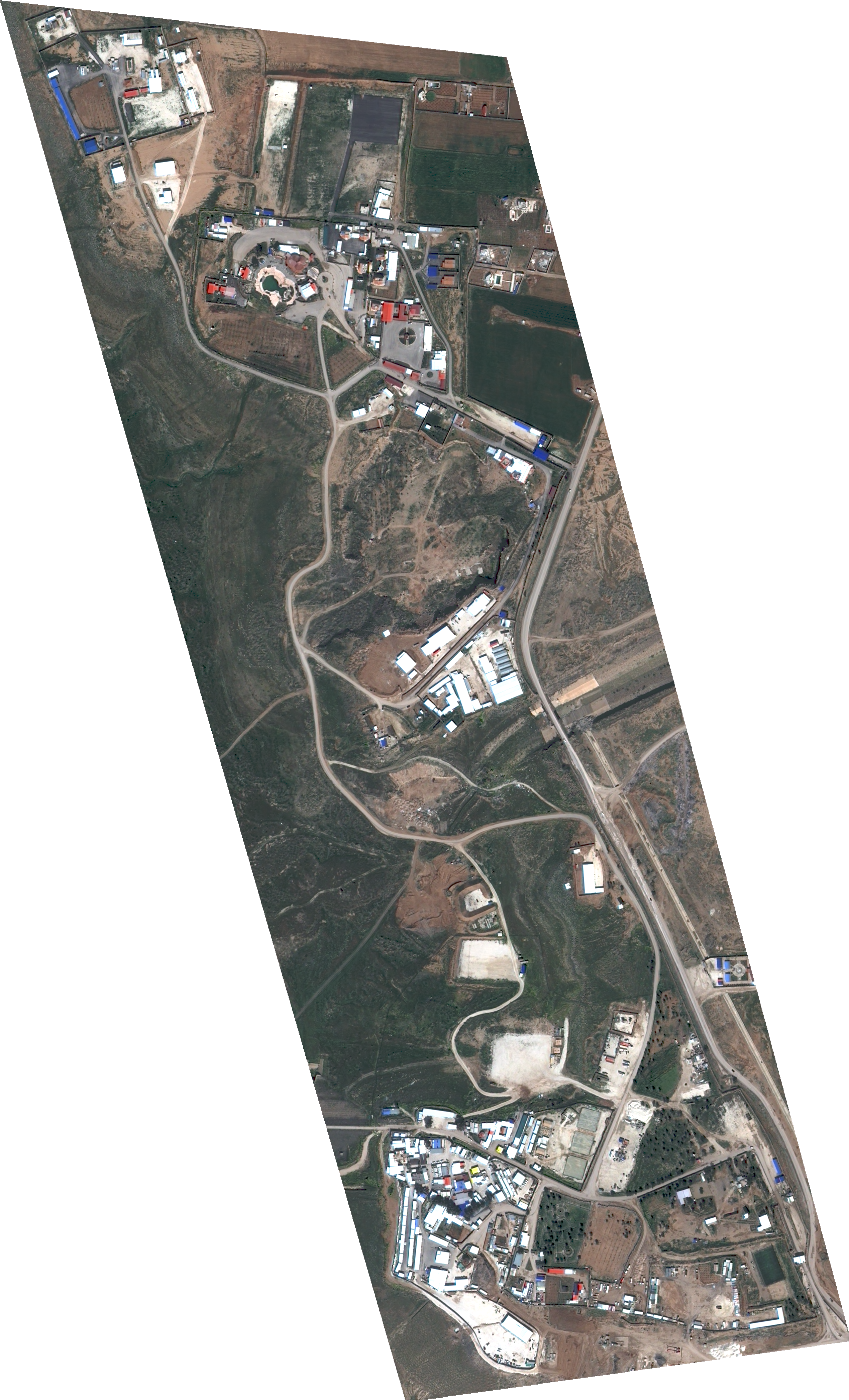
Images below: an American flag seen from the road in 2019, 2019 CNN footage from the base, a 2025 protest against the SCG’s ‘Constitutional Declaration,’ women protesting over children reportedly kidnapped by the ‘Revolutionary Youth’ movement, a shot of northern warehouses (likely SDF) from the east, two Ospreys and 2 Chinooks north of the Life Stone resort in 2017.


Dêrik (official name unknown)
aka al-Malikiyah, Khirbat al-‘Adnan, Girê Kera. al-Hasakah, 37.154521, 42.149641.

This base is located in the northeastern most corner of Syria, approximately 1.5km southeast of the city of Dêrik/al-Malikiyah and just outside the village of Girê Kera/Khirbat al-‘Adnan. The US appears to have begun building the base at some point before July 2016, expanding it to its current footprint the year later. It features a helipad and a shooting range. In August 2022 Russian state-linked media published footage (below) taken of the base from a Russian military helicopter, the only imagery I’ve seen.
Ghweiran (official name unknown)
al-Hasakah, 36.483681, 40.750454.
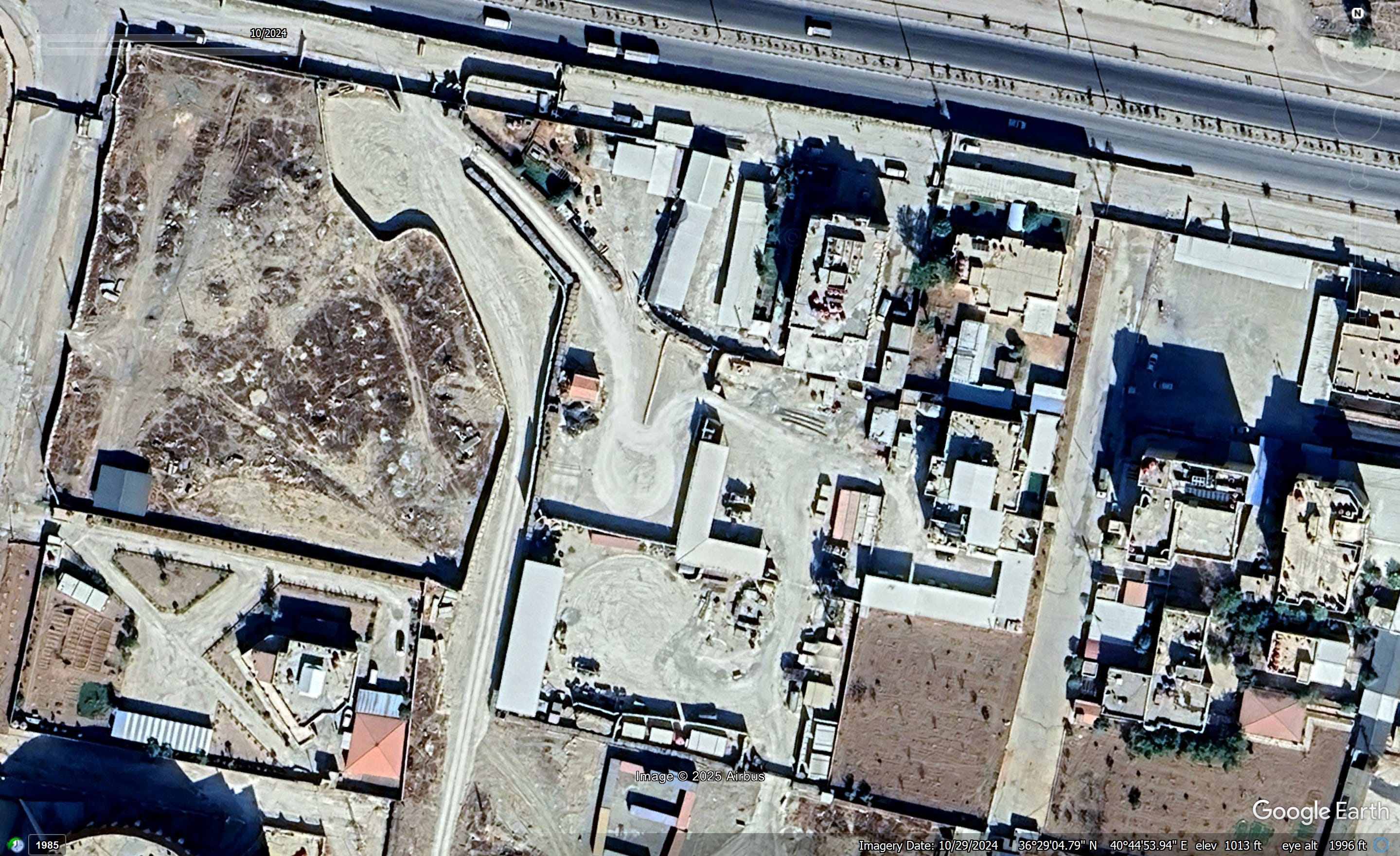
This is the only US base to be built after October 2019, with construction beginning the following February. It’s located in the Ghweiran neighborhood of al-Hasakah city, approximately 2km northwest of the al-Sina’a/Panorama prison holding former IS fighters. The base was constructed around previous government administrative buildings and abuts a complex presumably operated by DAANES or the some SDF body. A helipad, shooting range, and training grounds were built in the empty lot just to the south.

Images below: base construction in Feb 2020, a Chinook landing behind the base in 2022, US soldiers at the base in 2022 or earlier, stills from a 2022 protest denouncing Turkish drone strikes.


Mission Support Site Euphrates
aka MSS Euphrates, formerly MSS Conoco (until Nov 2023). Deir ez-Zour, 35.342585, 40.319033

Built at the site of the Conoco Gas Plant approximately 15km east of the Deir ez-Zour city. The plant was captured by the SDF and coalition from IS in 2017, while US usage of the site seems to have began in early 2018. MSS Euphrates formerly sat under four kilometers away from the former regime’s ‘seven villages’ pocket, from which the failed Wagner and regime attack on the Conoco field (aka the Battle of Khasham) was launched in 2018.
Images below: a WSJ reporter visiting in 2021, a Chinook in 2021, a howitzer crew in 2021, a howitzer crew in 2022, distance view of the aerostat balloon in 2022, the gym c. 2021, the aerostat via satellite, two howitzer positions via satellite, a sticker for sale made by military personnel.


Mission Support Site Green Village
aka MSS Green Village, Omar Oil Field. Deir ez-Zour, 35.050752, 40.559612.
MSS Green Village takes up a portion of the deserted ‘Green Village’ housing complex, originally built for employees of the nearby al-Omar oil field. It’s located in the Dhiban subdistrict of Deir ez-Zour, approximately 40km southeast of MSS Euphrates. Construction of the base began in early 2018. Around that time US forces appear to have been stationed at the Omar oil field administrative complex, but it’s unclear to me whether they still maintain a presence there. At least some of the buildings in the main complex are controlled by the SDF, as confirmed by the deaths of a number of fighters in a February 2024 drone strike. The US has built two airstrips in the area: an initial 1.05km long tarmac in close proximity to the administrative complex, and a more recently constructed 1.45km long strip in the vicinity of the Green Village.

Images below: Gen. Frank McKenzie visiting in 2020, Christmas 2019, a mortar team in 2020, an Osprey in 2019, a Black Hawk in 2021, Black Hawks and Apaches in 2019, HIMARS launches in 2021, a HIMARS firing in 2018, a MSS GV hat.


Other sites linked to US deployment
Hemo, al-Hasakah, 37.053730, 41.152188.

Formerly the Asayish General Command headquarters, currently the Asayish Law Enforcement Training Academy. Site of US training exercises for Asayish and its counter-terrorism units Hêzên Antî Teror (HAT). It was targeted twice by ‘The Islamic Resistance in al-Iraq’ in January 2024, sparking reports in local media alleging the temporarily US pulled whatever forces it had from the facility.

Features second training grounds (above) located 1.5km to the northeast which was videotaped from above by a Russian drone in August 2022 (below).
Images below: Photos published by the DoD in 2023 showing Asayish training courses, US forces entering the facility in Nov 2019.


Rûbariyê airstrip, aka Rahibah airstrip. al-Hasakah, 37.116290, 42.083797.

Former Syrian Ministry of Agriculture runway lengthened and repaved in 2015 and 2016, with a defensive berms dug around perimeter. Occasionally used by US aircraft through at least October 2022 (see below).
New Bridge facility, al-Raqqah, 35.932424, 38.993628.

American helicopters and armored vehicles were seen here (below) in late January 2025, however there’s no sign of a permanent US military presence at this site. Instead it appears to be a DAANES compound - likely Asayish - which was temporarily used during some sort of visit. The US is also rumored to use the Division 17 base north of the city in a similar manner.


Mizgefte, al-Hasakah, 37.065754, 41.591893.

An alleged US facility of some kind near the Mizgefte dam of northern al-Hasakah. From the photos and the satellite imagery it doesn’t look like a US military site, but I was told by someone who visited the lake (a popular tourist destination) around the time these photos were taken that this compound was a US/SDF military site with US flags flying over it. I have no other information or images but I’ve included it in case something else comes up.


Former US military bases vacated in October 2019:
Kobani Landing Zone (KLZ), Aleppo, 36.648851, 38.302811.
Lafarge Cement Plant, Aleppo, 36.543126, 38.587144.
Manbij, Aleppo, 36.495144, 37.825775.
‘Lawn Chair’/Sajour line, Aleppo, 36.611399, 37.927629.
‘Ain ‘Isa, al-Raqqah, 36.385159, 38.873532.
Tell al-Samn, al-Raqqah, 36.258249, 38.931417.
Harqalah, al-Raqqah, 35.957383, 38.939696.