


Google Earth finally updates its imagery for Afrin city (p.2)
Military, security, and governance sites
The first segment of this post examined the status of archaeological sites and forests in Afrin city and the surrounding countryside. This segment will examine sites related to security and governance apparatuses set up by Turkey and its militant and civilian proxies. Many of the structures highlighted have been built following 2018’s ‘Operation Olive Branch,’ though some date back earlier and have been repurposed in this time period.
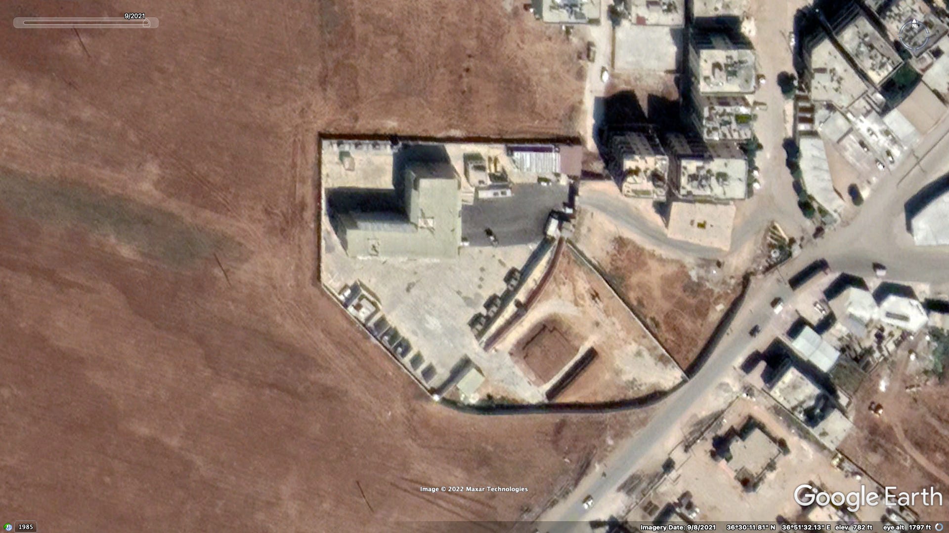
Turkish Military bases
Following Turkey's invasion of Afrin in 2018, several Turkish bases have been established in the region, particularly along the front lines with SDF and regime-controlled territory. Construction of nine walled off bases began in spring and summer 2019, however building seems to have paused indefinitely at three such sites located deeper into the region for reasons unknown. These front line bases have occasionally been photographed from a distance by SDF-linked military bodies and the press, however I have yet to see any photographs or video taken up close. Blast walls, tanks, heavy weaponry, and sandbag and dirt emplacements are the main features which allow these sites to be identified as belonging to the Turkish military rather than SNA groups.
1a. Kimar
Location: 36.430120, 36.896370

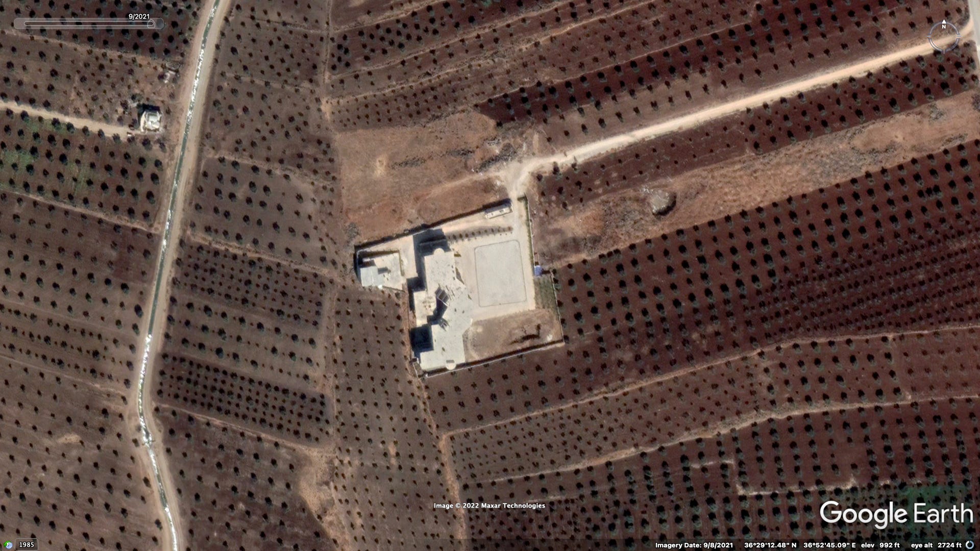
1b. Kimar
Location: 36.418731, 36.896583
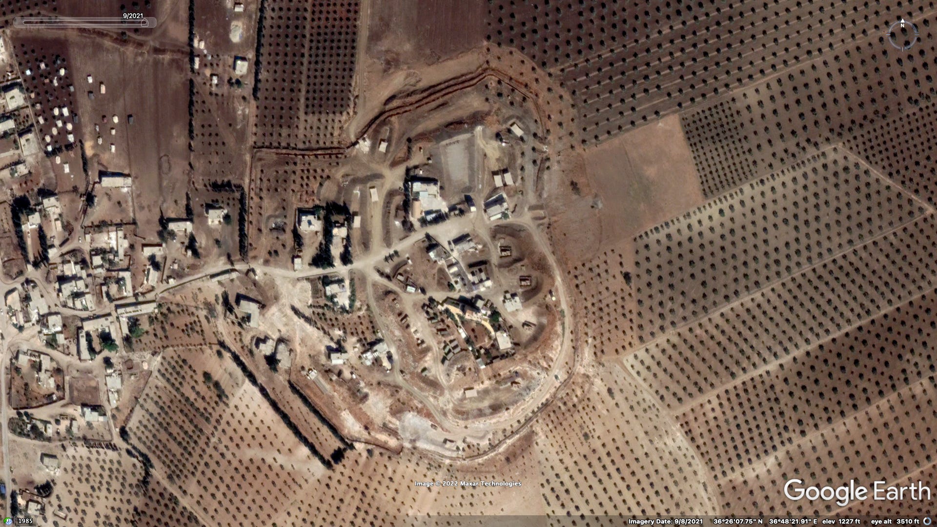
Former school building

2. Tilifê
Location: 36.434985, 36.806102
YPG had previously fortified this hilltop, digging tunnels leading from the southern and eastern sides to the summit c. 2014-15.
Its use by the Turkish military predates the walled in bases, with military vehicles first appearing in satellite imagery captured in May 2018.
Security compounds
These compounds house a number of different Turkish and Syrian institutions largely responsible for internal regional security. Chief among these are the Turkish Jandarma and Police Special Forces, both affiliated with Turkey’s Ministry of the Interior and together making up the ‘Syrian Task Force.’ Syrian authorities consist of the Civil Police, with several specialized branches, and the Military Police, affiliated with the Syrian Interim Government's Ministry of Defense and staffed by members of different SNA armed factions. Much of the information provided below comes from an investigation I conducted last year into a visit by Turkish Minister of the Interior Süleyman Soylu.
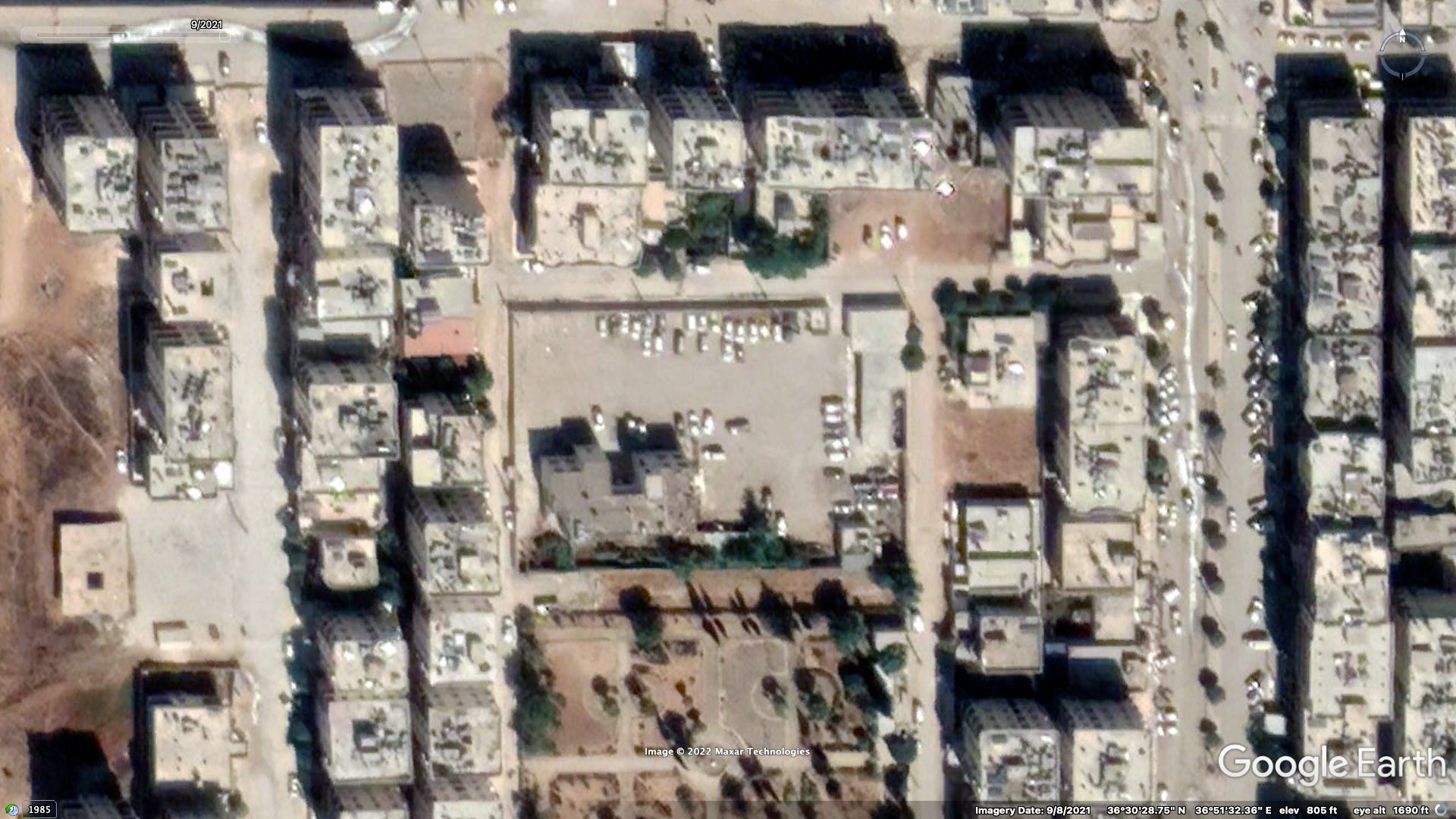
1. Security Campus
Location: 36.509437, 36.858293
Includes: City Security Management System Building, General Security Directorate, Palace of Justice/Afrin Courthouse, Political Security Branch, Hatay Governor’s Guesthouse, possibly a Turkish Jandarma base, and al-Shifa’ hospital (seen in the center after partial demolition due to damaged sustained in a June 2021 rocket attack)

2. Faisal Qaddour School
Location: 36.503190, 36.858929
Former school
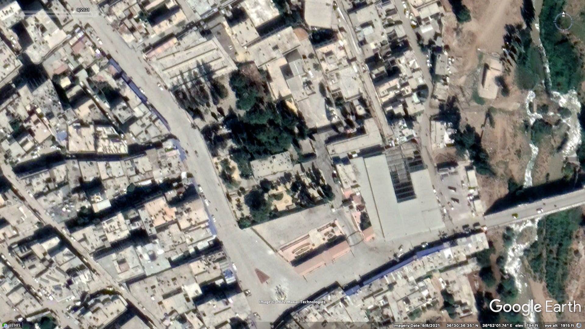
3. The Serail
Location: 36.509796, 36.867144
‘Humanitarian Coordination Center’ (İnsani Yardım Koordinasyon Merkezi)
Likely headquarters of the Turkey’s ‘Disaster and Emergency Management Presidency’ (AFAD), possibly state-linked NGOs as well.
Former center of local government during French Mandate period
4. SNA Military Police HQ
Location: 36.507763, 36.858927
November 2020 images from Afrin Military Police’s Facebook page
Former school
5. Afrin Central Prison (‘Marate Prison’)
Location: 36.501814, 36.833196
September 2020 video report from the SNC
Previously an Asayish prison

SNA headquarters
This is a collection of SNA facilities that I'd previously identified through geolocated video and images. The properties vary in size, layout, and use. Some appear to be headquarters for local affiliate brigades, while others appear to be training grounds - some even containing barracks. Furthermore, some of these facilities are reportedly used as detention facilities.
1. Furqat al-Sultan Murad - Mesh’ale
Location: 36.569775, 36.910957
Targeted by Russian airstrikes May 2022

2. Furqat al-Sultan Murad - Qere Tepe
Location: 36.551749, 36.890807
December 2020 training video

3. Faylaq al-Rahman - Brigade 135
Location: 36.539906, 36.917506
January 2022 training video
Old SAA base from before the war (the only Syrian military base in Afrin at the time), was taken over by the Asayish following the regime’s withdrawal from the region in 2012

4. Jaysh al-Islam - al-Ashrafiyah
Location: 36.509442, 36.871004
February 2021 photographs

5. al-Jabhah al-Shamiyah (al-Liwa’ 51) - al-Ashrafiyah
Location: 36.508845, 36.870897
I am currently unable to find whatever it was that allowed me to determine the subfaction but here’s a June 2022 video in front of the facility with a giant ‘Third Legion’ (led by al-Jabhah al-Shamiyah) sign out front

6. Liwa’ al-Shamal - al-Siyasiyah St.
Location: 36.509138, 36.863122
0:59 - 1:52 of this video July 2022 video

7. Harakat al-Tahrir wa’l-Bina’ (Jaysh al-Sharqiyah) - Cindires Rd.
Location: 36.490407, 36.843247
June 2022 video

8. Jaysh al-Islam - Turandah
Location: 36.486346, 36.879017
February 2021 video
9. Furqat al-Hamzah - Qala’at Basoutah
Location: 36.433385, 36.870268
A March 2018 photograph taken right after the town was captured. I know I’ve seen slightly more recent imagery, but I have to figure out which of the group’s Twitter accounts they were shared to.
reportedly used as a prison

10. Furqat al-Hamzah - Jabal al-Ahlam resort
Location: 36.435134, 36.882419
September 2021 photographs (Posted by Tha’iroun, but featuring Hamzah commander Saif Abu Bakr)
December 2020 HRE ATGM attack video
Former restaurant and garden

11. Furqat al-Hamzah - al-Basoutah/Kimar road
Location: 36.441170, 36.889655
September 2021 photographs (Posted by Tha’iroun, but featuring Hamzah commander Saif Abu Bakr)
More recent imagery I’ve seen shows this site has expanded since

12. Furqat al-Hamzah - Kiferê
Location: 36.427992, 36.861829
September 2022 photographs
On a hill mentioned in Part One as a site of significant deforestation (occurred in late 2018/early 219)

Afrin city checkpoints
Afrin city has four entrance points, each now heavily securitized due to car bomb attacks in the past. The checkpoints set up here are manned by the SNA Military Police, with CCTV feeds monitored by the Turkish General Directorate of Security deployment stationed in the ‘City Security Management System Building.’ Additionally there is a checkpoint on the road that bypasses the city to the east, allowing through traffic from A’zaz down to al-Ghazawiyah crossing into Idlib.
1. NW entrance - Rajo road
Location: 36.522729, 36.838541

2. SW entrance - Cindires road
Location: 36.494566, 36.850091

3. SE entrance - Turandah road
Location: 36.493876, 36.879105

4. NE entrance - A’zaz road
Location: 36.527840, 36.893227

5. Eastern bypass road
Location: 36.518803, 36.895410

Other
Kuwait al-Rahmah/Jabal al-Ahlam
Location: 36.482009, 36.907941
Read STJ’s report from earlier this year on this recently constructed settlement village built to house the families of SNA fighters as well as IDPs, highlighting the role Turkish officials and SNA factions played in the project.


Informal IDP camps
These are a relatively recent phenomenon, first appearing in Spring 2020 due to the influx of tens of thousands of displaced persons fleeing a regime offensive ongoing at the time in Idlib.
36.521126, 36.852437

36.505586, 36.867202

36.499643, 36.879323

Note how all open spaces in Afrin’s eastern al-Ashrafiyah neighborhood are now covered in tents

36.563581, 36.918047

