


The effects of the February 6th earthquake on Cindires
Syria's worst-hit city
At 4:17 AM on February 6th a massive earthquake struck Turkey’s Gaziantep province, approximately 43km north of the Syrian border. With a magnitude of 7.8 this was the largest earthquake experienced in Syria in over eight hundred years. The earthquake and the numerous large aftershocks that followed it immediately devastated southern Turkey and northwestern Syria. Thousands of multistory urban residential buildings collapsed, killing upwards of 60,000 people across the two countries.
Two months later it’s still unclear exactly how many people were killed by the earthquake and its aftereffects across the different statelets of Syria, but the total appears to be over 5,000. Compounding this tragedy are the more than 4,000 Syrian residents of Turkey who lost their lives in the earthquake as well.
According to figures reported by the Syrian regime’s Ministry of Health in February, 1,414 individuals were killed by the earthquake, with the provinces of Aleppo and Latakia the most affected. Only six people reportedly died in areas controlled by the Autonomous Administration (AANES) and the SDF, all residents of the al-Sheikh Maqsoud district of Aleppo city.
Opposition areas of Syria were the worst affected with the death toll as reported by the Syrian Network for Human Rights (SNHR) in late March reaching 4,191. A majority of these occurred in the Harim district of northwestern Idlib, with hundreds dying in many of its main cities and towns, including Harim, Salqin, Armanaz, and ‘Azmarin. Over a quarter of the total death toll in opposition regions came from the city of Cindires (also spelled Jindires, Jandaris), located in southwestern Afrin.
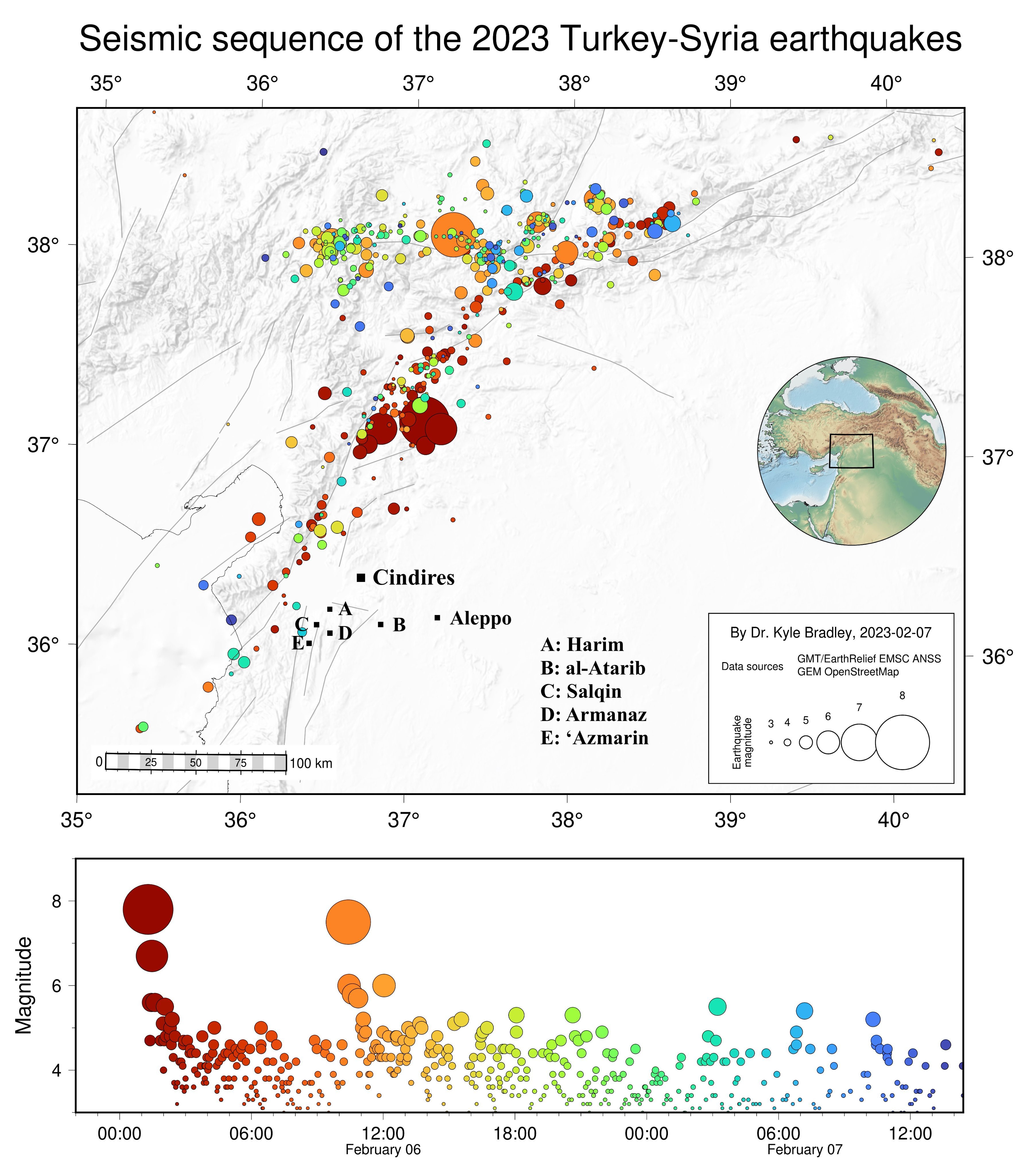
On February 7th the affiliated Cindires Local Council - responsible for administering the subdistrict of around sixty towns and villages - declared all of Cindires city a “disaster area.” The most recent figures published by the Local Council show 1,100 residents perished in the earthquake, more than half of whom were reportedly students enrolled in the Cindires school system. An additional 254 people died in the villages of the Cindires countryside (see SyriaTV video below on the affects of the earthquake on Hajj Hasanli village in northern Cindires). According to the Local Council 278 of the city’s buildings completely collapsed, while assessments made by engineers at the scene found as many as 90% of city’s buildings having suffered some form of damage.

Cindires is the second largest settlement in Aleppo’s Afrin district. According to the last Syrian census, taken in 2004, it was home to a population of 14,000. This number has increased dramatically ever since, particularly since the conflict started in 2011. In the subsequent years, while the region was governed by what’s become known as the Autonomous Administration, Afrin attracted significant numbers of Syrians fleeing fighting elsewhere, many coming from in and around Aleppo city. Following the Turkish capture of the region in 2018, tens of thousands of people displaced from regime advances further south have arrived in Afrin, many settling in Cindires city and its countryside.


According to the Cindires Local Council, the city’s pre-earthquake population numbered 115,000. Accompanying this massive increase in population was a physical expansion of the city, both upwards and outwards. Dozens of multi-story apartment buildings were constructed over these two periods. Construction quality, both prior to and during the war, has been lacking due to a number of factors.


Click here to view a 3D aerial photograph of Cindires post-earthquake, posted to Facebook on February 19.
An article published by The Syria Report elaborated on some of these issue:
“Most buildings in [Cindires] were unlicensed. Historically, the town is remote and has received little government or municipal attention. [Cindires]’ zoning plans are old and not adhered to by any local municipality, just as structural safety standards for construction were not followed during any period of control over the town, given its remote location…
A structural engineer in the area told The Syria Report that, during the various periods of control over the town, no local municipality or independent engineering committee conducted soil tests or studied soil mechanics…
The engineer added that most of the building foundations in the town did not reach the rocky layer beneath the soil and that appropriate engineering methods were not followed. Multi-storey buildings…did not take into account the additional load on the soil and did not feature appropriate foundations. Finally, the engineer added that, during no period of control of [Cindires], no local authorities enforced mandatory construction permits that would take into account The Syrian Arab Code for the Design and Implementation of Reinforced Concrete Structures, which implement earthquake-resistant concrete reinforcements. Such reinforcements would have protected many buildings from collapse and limited the loss of life and property.”
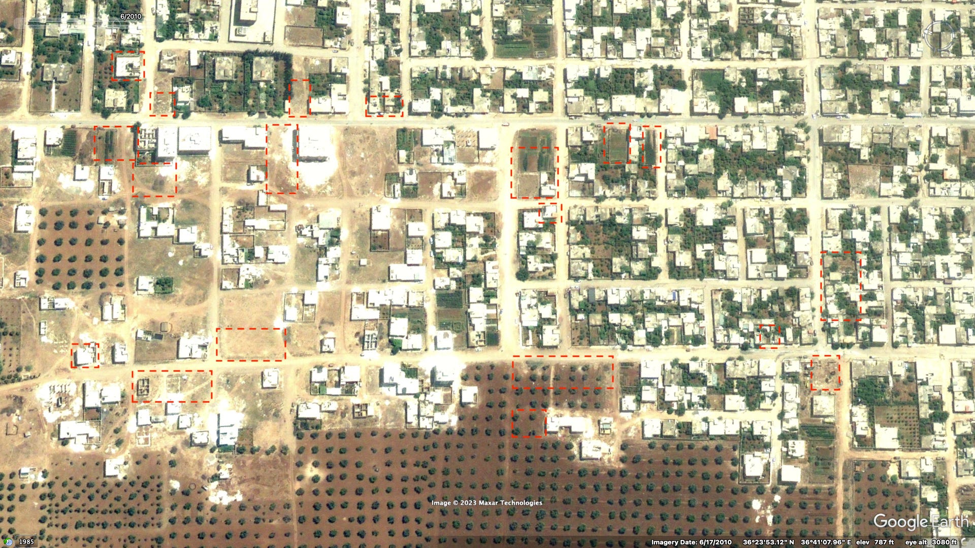
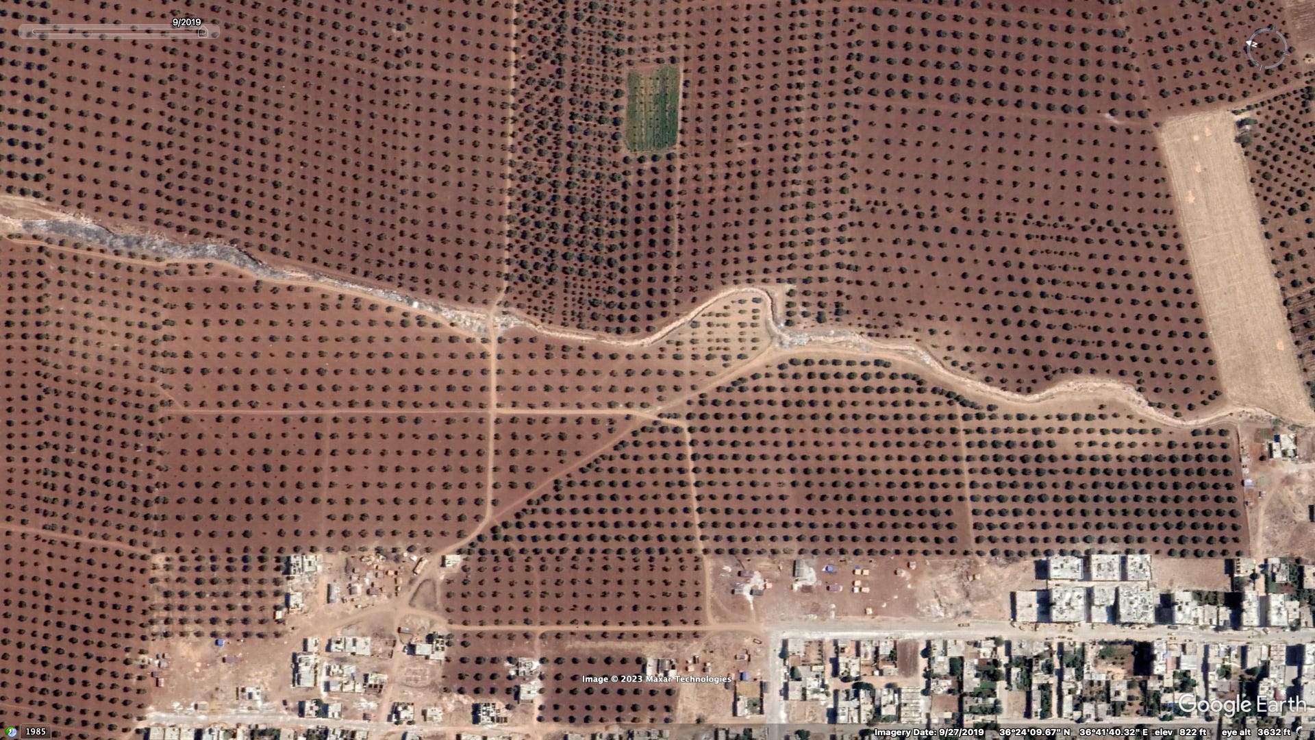
While The Syria Report alleges most of the collapsed buildings were constructed post-2018, analysis of satellite imagery shows that many of the largest collapsed apartment buildings date back to the previous period, while the region was under Autonomous Administration control and largely shut off from the broader Syrian economy due to tense relations with the surrounding opposition areas. As has been the case elsewhere, it’s likely that some of these buildings were expanded vertically with additional floors, following initial construction.
For example see the satellite imagery of western Cindires below from (1) after the earthquake, (2) late 2017, prior to the invasion, and (3) from 2010.


New neighborhoods built on the city’s eastern outskirts post-2019 also suffered collapses.

As elsewhere in opposition-controlled Syria, emergency response efforts in Cindires were greatly hampered by the slow and limited arrival of international assistance. Over the years, Russia has used its seat on the UN Security Council to slowly restrict UN cross-border aid to opposition areas from multiple crossings to just the Bab al-Hawa crossing in Idlib. The main highway from Antakya to Bab al-Hawa suffered significant earthquake-related damage (footage below shows the road around the village of Demirköprü).

The first UN convoy passed through Bab al-Hawa on February 10th, however this to affected areas in Idlib. Reporting from Cindires that day found that “the only visible aid distribution came from local charities — plastic bags of food and blankets piled on flatbed trucks.” The following week, the Syrian regime allowed for the UN usage of two additional crossings into opposition areas, at Bab al-Salamah, located just north of A‘zaz, and at al-Ra’i. Around the same time aid convoys from the Gulf and some other countries began entering directedly into Afrin through the Hammam border crossing just west of Cindires city.

Despite the eventual arrival of international assistance to Cindires, the situation remains bleak. Two months later and city streets remain obstructed by the rubble of fallen buildings, efforts to remove such are estimated to take months at least. A dozen or more large tent camps have been erected to house the city’s former inhabitants, left homeless as with hundreds of buildings still standing deemed structurally unsound. Local authorities including Syrian National Army factions have been accused of corrupt and prejudicial aid distribution practices.
